Reduce, reuse, recycle: Civic apps start to spread
Open data, hackathons, "incubators," civically-minded geeks riding to the rescue of communities across the globe -- what could possibly be wrong with that?
Plenty of things, actually: flimsy, throwaway apps that never see use, herds of nerds producing the same bus schedule app that every civic hackathon produces, incubators that are meant to produce companies but produce little except press releases and a massive timesink for entrepreneurs. Open data may not have the intended effect and may increase self-segregation, or allow powerful players to centralize at the expense of grassroots organizations.
What if app fever -- and its fellow travelers, hackathons, incubators, and seed funding contests, and Kickstarter campaigns -- are simply a distraction from the work of building something that has a hope of making an impact?
In short, how do we know it's working?
One major test is this: does the app outlive its initial use case? Does it get re-used by other communities?
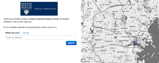
I was thinking about this recently, as the city I live in -- Boston -- declared a public health emergency in the face of a flu outbreak that some people estimated as having ten times the number of flu cases as the previous year.
While it might be possible to write a quick and dirty app fast enough to outpace a growing epidemic, the team at Boston's New Urban Mechanics decided not to do that: they re-used Chicago's flu shot app to quickly distribute information about where immunizations were still available.
I asked Michael Evans of New Urban Mechanics what the process is for suggesting or deploying open-source apps. "The process for suggesting open-source apps is pretty loose. With flu shot, we knew about the app late last year from Twitter and word of mouth...A couple of weeks ago, some folks on the city's web team heard about the app [again] via Twitter and suggested that it might be a good alternative to ArcGIS maps.
ArcGIS maps are produced by expensive geographic information system (GIS) software that's typically only accessible to highly trained individuals. While the maps that are produced can be viewed by anyone, they are not always as accessible and flexible as modern web-based mapping platforms.
This blog is made possible by a grant from the John S. and James L. Knight Foundation.
